Help With Shopping On Location

1041px-holt_renfrew_mannequins
en.wikipedia.org/wiki/Mannequin

Whenever I go shopping, I am always attracted to the outfits on the mannequins in the windows and throughout the store. These outfits are always well planned, match well, and stylish, so I immediately begin my search throughout the store to find these items. I begin by looking near the mannequin. When I do not find the items I’m looking for, I skim the rest of the store. Finally, I will try and find a sales associate for their assistance. This is a tedious process and can end without success.

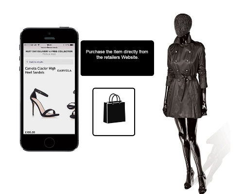
Iconeme is an app that will alert customers when they are 50 meters away from the mannequin. This alert will include information about what items are on the mannequin, prices, locations in the store, and a link to where the items can be bought online. The app also allows users to share their favorite items with friends which allows users to shop with their friends while not being physically together.

iconeme
Iconeme App  evigo.com/15964-house-fraser-ibeacon-mannequins-mobilize-store-shopping/

The app also allows for retailers to track a customer’s location in the store. This provides them with information about how long each customer looks at an item and their path throughout the store. With this information, retailers can tailor the layout of their store to better serve their customers.

Stores are using apps, such as Iconeme, to bring customers into stores as online shopping becomes more prevalent. One study showed that 60% of Americans are happy shopping online instead of in a crowded mall, and 71% of shoppers believe they will receive a better deal online than in store. The mall in my home town for example is slowing loosing stores to online shopping and is becoming more barren everyday. In a hope to revive in store shopping, retailers are using Inconeme to make shopping in store a more interactive experience.

While Inconeme is a great way to make shopping more interactive and easy, the app is primarily located within the United Kingdom. As technology advances, hopefully more stores will be able to use location based services since it brings an eases to shopping. This would allow for customers to quickly find their items without the hassle of talking to a sales associate or wandering throughout the store searching for items. Apps, such as Iconeme, could make the process of shopping in store more streamline and efficient while making the process less stressful.


Looking into the Past

When walking through a city that is new to me or even my home town, I wonder what that location used to look like. I wonder what the history took place at that location, if a battle was fought there or if a grand building stood there.

icon175x175
History Here itunes.apple.com

History Here is an award winning app that provides historic information about locations across the United States. When the app is open, the information about the location can vary from architecture to museums to famous homes and people.

When I opened the app at College Park, I learned some new and interesting facts that I probably would not have known otherwise. For example, the College Park Airport is the world’s longest continuously operating airport and that it was home to the first U.S. Postal Air Mail Service.

piccadilly_circus_0
Streetmuseum http://www.creativereview.co.uk/streetmuseum-iphone-app/

The Museum of London has an app called Streetmuseum that is similar to History Here. Streetmuseum gives users history about their location but it also overlays a picture of the location in the past when the user holds their phone to the street. This provides tourist or locals in London the chance to learn more about the history of London in an interactive manner.

Location based apps that provide a look into the past could change how students learn history. According to the National Training Laboratories in Betel, Maine, students only remember 5% of what they hear in lecture but when they are actively engaged this percentage increases drastically. These apps could drastically increase students chances of remembering the information about the history since they would be actively engaged in learning the information instead of sitting in a lecture hall.

While they can increase the chance that a student will learn the information, they also provide the chance for the public to learn more about their surroundings without having to go to a museum or having a tour guide in a new city. These apps may also help to expose tourists to the culture of a location since they are able to see major events in the past that shaped the location. I personally know that I won’t forget the information that I have already learned using these apps since I learned the information using my location.

Uber: Driving without Driving

24345560812_c02e12e8ea_b
Surge Charge Pricing https://www.flickr.com/photos/avlxyz/24345560812

In a city with lots of traffic, people no longer want to or have to drive their own cars. Instead, they opt for services like Uber when they need to drive somewhere.

Uber allows for passengers to request a ride from a location  24/7. They will receive information about the driver’s first name, type of car, and license plate number. As the vehicle approaches, passengers will be able to track its location, and they will receive a message when the vehicle arrives at the location. When the ride is over, the charge is calculated and paid through the passenger’s Uber account.

Uber seems very simple and easy, but some of Uber’s policies cause users to think twice about taking a ride. When the demand for cars is high, Uber will add a surge charge to a trip, potentially doubling the cost. Surge charges may cause some people to delay their rides, or they may decide to pat this extra cost. Uber has recently introduced self driving cars to the road. Before customers were given rides in these cars, they mapped out the streets by beginning in Pittsburgh, since these streets are narrow and have extreme weather conditions. At the beginning of the September, 2016 a dozen of these cars were released onto the streets of Pittsburgh and use location services to drive around the city.

26685190944_a7672d46dc_b
Uber Self Driving Car https://www.flickr.com/photos/iwasaround/26685190944

While self driving cars seem like a good idea, Uber currently still has a driver sit in the car in case anything happens to go wrong. Eventually, these people will be removed from the cars as the cars become more refined. When this happens, passengers may become more passive in their travels since a robot is basically delivering them to their location or it may lower the number of accidents since it will remove human error.

With over eight million users and two billion rides in 400 cities since they were created,
Uber could greatly impact driving. The ease of being able to call a ride up within minutes has been a leading cause of their growth. They introduced self driving cars to the roads and are using the location and number of Uber cars to determine if a surge charge is necessary. By expanding on their already present location systems in place, such as the mapping of Pittsburgh, they could determine the best route possible for an Uber based on the traffic. This could help to eliminate surge charges and make driving more efficient in general by avoiding traffic jams.


Assisted Flying

When I was thirteen years old, I flew from Baltimore to Alabama by myself to visit my

airport
Airport Terminal https://en.wikipedia.org/wiki/Airport_terminal

Uncle. I felt nervous leading up to my flight, even though I had flown before with my parents. Instead of traveling with my parents, this time I had to walk away from them after checking my luggage. I remember the tears welling up in my eyes as I walked through the security and waved goodbye to them. I feared that I would get lost in the airport and then miss my flight.

I am not the only one that feared getting lost in airports. One study showed that 50% of travelers cannot find what they are searching for in airports.

Five years after I flew alone, there is an app for locating services in airports, including the Chicago, Los Angeles, Miami, Phoenix, and San Jose airports. The app is able to direct people turn by turn to their destination in the airport, so people never get lost! It allows travelers to find their gate, locate food, or facilities around the concourse, and when they head in the wrong direction the app is able to turn them around and direct them on the right path.

Another feature is that the app, called “wayfinding,” can provide relevant information to passengers’ locations throughout the airport. Depending on whether a traveler is parking, checking in, or approaching their gate, they will receive different notifications  and tips to help make their journey uncomplicated.

gate
Airport Gate https://en.wikipedia.org/wiki/Expansion_of_Gatwick_Airport

These location services bring an ease to airports that makes the process of flying simpler and faster paced. Travelers no longer need to look for signs leading them to the right gate or the bathroom or ask for directions when they are lost. They can just search for what they are looking for and then follow the apps directions turn by turn.

While this app makes traveling easier, especially in new and unfamiliar airports, it also makes us slightly absent when traveling. For example, one time when my mom was flying home from Texas, she ran into a good friend she had not seen for years. If she had been absorbed in her phone with directions to her gate or the bathroom, she may have missed the opportunity to catch up with an old friend.

Location services in airports add to the fast paced, technology driven society that we live in today by making traveling less stressful for many people. If I would have had such an app when traveling to Alabama, the experience would have been a lot smoother for me.

Social Locations

Life Through Locations will explore the use of location services and the positive and negative impacts that they have on our lives since many aspects of our everyday lives revolve around these services.

Many people use location services on social media, such as Facebook, Instagram, Twitter, and Snapchat. These services allow for people to connect with other users around the world and to find new and interesting locations. While people do enjoy sharing their location, many do not realize how much they are sharing with others.

On Facebook, people can share their location by “checking in” or by sending t

2000px-facebook_messenger_logo-svg
Facebook Messenger play.google.com

heir locations through the messenger app. While this appears to be a cool feature of the app, there is a Google Chrome extension called Marauder’s Map where users can find a person’s exact location through the messenger app, if the person’s location services are enabled. With this extension, users do not have to be friends for others to be able to see their location. As long as their location service is turned on and they have communicated through messenger, people can find their exact location.

insta-photo-map
My Instagram Map

Users on Instagram can easily add a location to their photos when initially posting the photo or by editing their photos. This option adds the photo to the users photo map. If they frequently upload photos from the same location and their account is public, others users may be able to detect where they are located. When looking at my photo map for example, I have many photos posted at the University of Maryland and my hometown, showing that these locations are where I spend most of my time.

When a users tweets, they have the option to add a location to their tweets. Snapchat users can add a location specific filter to their pictures and add Snapchats to location based stories.

These location services are optional for users but many opt in to use them. People do not have to add locations to their pictures or posts, but they will go to specific locations to take pictures to post on social media or to use unique Snapchat filters. I know that I always look forward to new Snapchat filters when I go to new places and that I seek out specific locations when I travel places to post that photo on Instagram. However, by using these services, people are exposing their exact location to strangers if they are not careful with their privacy settings.